
Overcrowding 4) How Did We Get Here? Flawed Icons
Exploring how iconic destinations are vulnerable, even flawed icons

Welcome to our series on overcrowding, examining how we got here and where we go next to find new solitude.
Anymore, the picturesque rivers in Montana, the pristine waters of Biscayne Bay, just aren’t the same places that they used to be. Far and wide, the angling world is more aware of itself as a whole than at any previous point in history. With enough money you can book a ticket to just about any notable fishery, armed with flies, locations, maps, guides… enough resources to look like a pro. Then rumors spread, the best of the best climb to a supreme status, held in the highest regard. Grand Bahama, the Henry’s Fork, the Missouri, the White, the Green, Christmas Island, the South Platte, North Platte, the St. Lawrence, etc…
Let’s dig in more closely at my first two examples and explore how these iconic destinations are vulnerable, even flawed icons.
1. Montana
Montana has been grappling with dwindling fish counts all while more and more anglers are exploring and crowding the famous rivers found in the southwestern portion of the state. Like most of the West, snowpack variability, droughts, floods, and aging dam infrastructure have all impacted these Montana streams in recent years, largely thanks to climate change.
Climate change is disrupting the water cycle, starting with the timing of spring runoff. More and more soot, dust, and other dark light absorptive particles have been introduced into the atmosphere from burning carbon, food production, clear-cutting, land development, and other industrial processes. Later these dark particles are deposited on top of snow far from their original source. Once temperatures begin to warm in the spring, the dark dusty particles that fell with or settled upon the snow reduce the reflective surface and cause faster rates of snowmelt. Scientists have documented evidence that human-derived particles are decreasing alpine snow albedo causing earlier spring peak runoff. These effects are seen all across the West and have led to some concerns about how water will be provided to downstream states, furthest from the snowmelt source. When scientists specifically looked at these effects of the Colorado River around Lee's Ferry, Arizona, they found that dust had accelerated spring peak runoff by several weeks, coupled with enough evaporation to decrease annual flow by 5%. They also estimated that the 5% loss would be enough to water Las Vegas for 18 months! So we're not talking about small amounts; the influence of human-induced dust is concerning for many western water managers, though the problem persists globally, too. Similar reports have been documented in the world's most famous mountain range: the Himalayas. But when spring runoff happens earlier, prolonged delivery of cool water over the summer dwindles.
As spring runoff occurs earlier in the year, Rocky Mountain streams lose their snowy reserves held in the high alpine zone leading to decreased summer flows, increased stream temperatures, and rivers that reach base flow earlier in the season. These reduced flow conditions stress trout, impact their spawning behavior, and impact the larger river ecosystem. Earlier spring runoff events can even worsen the effects of drought and increase the risk for wildfires, each climatically linked to climate change as well. According to a report by the Montana Department of Fish, Wildlife and Parks, "increased water temperatures, lower flows, and extreme events like floods and droughts are likely to have profound impacts on Montana’s aquatic ecosystems and the fish and wildlife that depend on them". The periodicity of natural disasters has also been impacted. During 2022, the Yellowstone river suffered one of the most astounding flooding events in our lifetime. Predicted as a 500-year flood, meaning the probability of this occurring any year is 0.2%, the river received between 7.5-9.5” of rain in 24 hours. Though estimated as an unlikely, statistically abnormal event, some evidence suggests that with increased global temperatures, and more liquid water entering the oceans from melting ice, the old paradigm of 50 year floods, or 100 year floods, or 500 year floods are more likely to occur more frequently than their names suggest.
Not only are natural disasters playing a role, but humans, who’ve inserted themselves into Montana’s water cycle also hold certain fate cards for their fisheries. In late 2021, a Hebgen Dam malfunction cut off 50% of all flow into the Madison River for 46 hours, during the fall spawning activities of naturalized brown trout. Though some have come out after the fact claiming no long term repercussions were caused on the fishery, aging infrastructure (like the 108 year old Hebgen Dam) can unexpectedly impact fisheries across the west due to mechanical failures, not just in Montana. Many similar, notable freshwater fisheries in the west fall downstream of dams.
Increased temperatures are also predicted for the rivers and streams in Montana. A 2016 study published in the journal Global Change Biology found that climate change is likely to reduce the distribution and habitat suitability of several trout species in Montana, including the Westslope cutthroat trout and the rainbow trout. But it’s not only fish. The iconic salmonfly is also losing ground in Montana, and western rivers. The inspiration for the Bunyan Bug, highlighted in the film “A River Runs Through It”, the salmonfly couldn’t be more iconic in the annals of fly fishing. But salmonflies are disappearing. Loses have been reported in prized fisheries across the western US, including Blue Ribbon Fisheries like the Madison, Logan, and Provo Rivers. In some rivers, declines have been subtle - only on small stretches. In others, salmonflies have disappeared entirely. Salmonflies are highly sensitive to environmental changes, and the cocktail of increasing water temperature, disrupted flow, increased sedimentation and pollution, and disturbances to food webs are responsible for one nasty, even lethal Salmonfly hangover.
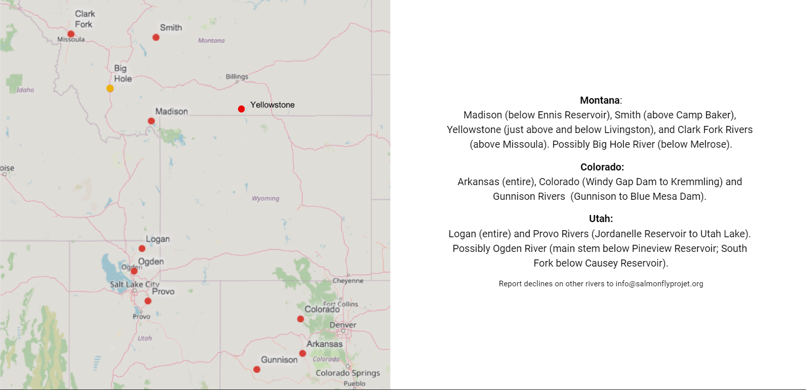
Source: The Salmonfly Project
A huge question remains, how does Montana continue to protect its aquatic natural resources and maintain their important revenue stream derived from outdoor recreation, including hunting and angling?
Think about what happens when you sprain your ankle. The best thing to do is minimize your exercise while it heals. So what happens if you keep running and sprain it again? And again?...
Overcrowding issues in Montana are finally coming to the attention of state officials.
Dealing with overcrowding
The issue of angling pressure is common on Montana's Madison River, an area extremely iconic amongst devout fly anglers. In 2017, river traffic reached an all time high, with 270,000 angling days recorded over the year. (Think of angling days as a proxy for fishing pressure.)
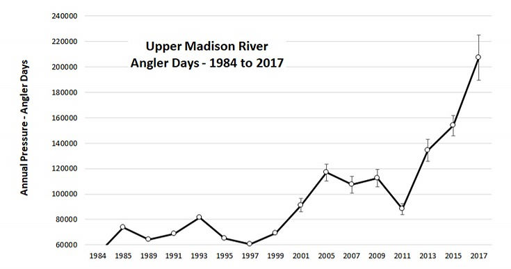
Source: Montana Fish,Wildlife and Parks
Needless to say, Montana's Fish, Wildlife, and Parks (FWP) has been looking for ways to address the overcrowding. A proposal was brought to the state Fish and Wildlife Commission in 2018, but proved wildly unpopular with guiding outfits as it would have metered guiding trips on the Madison, even prohibiting guides to access certain areas at certain times. The proposal was canned. Yet, public opinion polls have reinvigorated the commissions interest in finding a solution, and the newest proposal brings back a controversial rest and rotation schedule for commercial float trips. And as of 12/24/2020, the proposal had been adopted, kicking in starting in 2022, but was repealed by the end of 2021.
What was adopted? One of the ideas proposed and now adopted by Montana FWP is to restrict the daily number of guide trips, and restrict those trips from using certain sections along the river at certain times. Specifically, between June 15 and September 30th, commercial trips will be prohibited between certain day-use areas depending on the day of the week. There were other elements, involving wade angling and riverside development, but this was the rest and rotation system.
But this adopted solution has some opposition. Guiding operations didn't like the idea of capping use based on the 2019 levels, not accounting for population growth or increased angling interest for the future. They also argued that commercial outfitters are unfairly targeted by this proposal, and the rest and rotation would actually increase boating density on their regulated sections of river caused by bottlenecks. The ultimate argument against this rule focus on how the natural dispersal of anglers across the river system is discouraged. No longer would the boats diffuse naturally across the river, but now more would be forced into a smaller less diffuse route.
This shared resource (the Madison River and its excellent fishery) can be considered a shared common good, available to all. Over time, shared common resources tend to get exploited, as each individual (or guide service or whoever) tries to maximize their utility from the resource. After all, if I'm not using it to the fullest extent, someone else might be. But as everyone tries to take more and more, the shared common good is prone to rapid exploitation as each tries to make the most out of the shared resource for themselves. In the end, everyone degrades the shared resource out of self-interest. This is the tragedy of the commons that I introduced at the beginning of the series. And the problem with the tragedy of the commons, is that it’s really difficult for any one individual or organization to delay their use in the name of the greater good when others won’t do the same.
Some researchers have specifically investigated how to manage a catch-and-release fishery with special considerations for minimizing fish stress, injury, and mortality, in order to maintain or improve the quality of the fishery. One solution (albeit controversial) was to restrict access in order to regulate angling pressure. That's exactly what the rest and rotation proposal sets out to do on the Madison River, but many weren't pleased with these restrictions.
In fact, the approved rest and rotation boat regulation was repealed in December 2021, citing increased pressure in specific sections and industry pushback. Even though short term closures have been shown to decrease threat perception in rainbow trout, the benefit contradicts other cherished angling rights, like stream access. Montana's once proposed rest and rotation scheduling for limiting and regulating boat traffic could have provided fish with time to re-acclimate for the benefit of anglers, but that plan has been appealed. Clearly no one wants their access taken away, even if it's simply temporal access (change in timing). Meanwhile in Iceland, all rivers have a mandatory period of rest for 2 hours each day to minimize adverse effects from over-angling.
2. Biscayne Bay
Florida’s Biscayne Bay used to harbor world famous flats for both bonefish and tarpon. Though not totally forgotten, the bay's proximity to the urban populous of Miami and other southern Florida communities has introduced unexpected pollutants into the bay, negatively affecting seagrass and coral. The seagrasses common across the bay once helped filter water, and anchored the crystal clear flats. According to NOAA, these seagrass beds were large enough in size to rival Australia’s Great Barrier Reef System. The inshore habitats were bursting with fish, snook, tarpon, sea trout, just to name a few. Unfortunately, what makes these shallow flats so appealing for fish and anglers alike also made it vulnerable. These waters are also adjacent to a vibrant city. Possibly set in motion by back-to-back hurricanes starting in 2005, toxic algal blooms, fed by human derived sources of nitrogen and phosphorus, degraded seagrass, coral and sponge abundance, even some fish. With the seagrass goes the entire ecosystem.
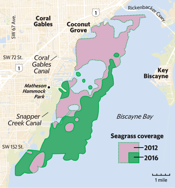
Source: Miami-Dade County and FIU
Now fish are less common within a bay struggling to address stormwater runoff, sewage, excessive fertilizers and other pollutants. Aging septic systems and excessive stormwater inputs are continually pumping unwanted phosphorus into the bay, especially when uneven precipitation upsets salinity. If the base of the existing ecosystem disappears completely, the entire system could shift into something completely different where returning to the old system is basically impossible. In a somewhat famous study, prescription drugs have even been found in the bonefish of Biscayne Bay, likely by accumulating up the food chain and eventually ingested by bonefish. The source? Human wastewater spilling into the bay. Despite the troubles in southern Florida, regulations deeming bonefish a catch and release species has helped their numbers bounce back. Once a ghost town for the ghosts of the flats, populations began to rebound after 2014. Yet, without an alternative for handling south Florida’s sewage and wastewater, there is still a suite of local issues to resolve.
Not to pile on, but all oceans are also facing ramifications from climate change. Most notably the movement of currents, weather patterns, and increased acidification of seawater. With excessive carbon dioxide in the atmosphere, more eventually ends up dissolving in the ocean. Chemically, these additions create carbonic acid, which breaks down into hydrogen ions and bicarbonate. It’s these additions of hydrogen ions that lower pH and increase the acidity of seawater. Important building blocks in the ocean's food webs are sensitive to these changes, including oysters, coral, plankton, and shellfish, when disrupted could have ripple effects up the food chains. Eventually impacting recreational fisheries.
Blurred Lines between Wild and Urban Places
What about those exotic and remote destinations? The fisheries found in remote wilderness or jungles or any other isolated habitat? Surely they are immune to some of these issues, right? Unfortunately, true wilderness is simply dwindling. Based on satellite imagery comparisons the Earth lost 10% of its global wilderness between 1993 and 2009, with almost 30% lost in South America alone. That’s not all though, wildplaces are smoldering at their edges. The areas where undeveloped natural lands come into direct contact with housing and other development, the wildland-urban interface (WUI), is rapidly expanding. In the United States, the WUI exploded from 1990 to 2020, introducing around 14 million new homes adjacent to undeveloped natural lands, and increasing 47% over that timespan. This type of development has ramifications for our fisheries, though not always directly. As vast wilderness is sliced up into smaller and smaller patches, ecosystems simply can’t function the same. The interconnectivity of wildlife is fractured with lasting ramifications for species reliant on larger continuous landscapes. For trout and salmon, culverts installed over streams during road development greatly impair fish movement and migrations, and introduce sediment into otherwise clear streams. Increases in impervious surfaces like roads, driveways, clear cut forests also disrupt the timing and path of runoff. The larger the fish, the larger the habitat requirements, the larger the home ranges. But the larger the fish, the more interested anglers tend to be. Plus, urban development, even minor development within wild areas disproportionately affects these species with large connective range, or migratory requirements.
Another example: Even though the Florida Everglades is technically one huge wide river system flowing south, that flow was cut off and dammed following several hurricanes during the 1990s. Now water movement must be facilitated by pumping stations through levees and canals, at the cost of thousands of acres of important wetlands. Once a wide, shallow, meandering river, it’s now a fragmented network of straight lines. So as our society grows, we encroach closer and closer to the previously pristine, and over time our presence becomes undeniable.
Further Reading
Useful Biology: What anglers can learn from the shape of a tail.
Gear: TFO's home run: the Axiom 2-x.
Sources:
- Bague, I. Accessed 2023. Pollution is killing Biscayne Bay, there’s very little time to save it, and it’s going to cost a lot of money to rescue it. https://www.miamichamber.com/news/pollution-killing-biscayne-bay-theres-very-little-time-save-it-and-its-going-cost-lot-money
- Goodhue, D. 2022. Cocktail of drugs taint bonefish in Biscayne Bay and Keys, study finds. Blame sewage. https://amp.miamiherald.com/news/local/environment/article258010233.html
- Pennisi, El. 2016. We’ve destroyed one-tenth of Earth’s wilderness in just 2 decades. Science. https://www.science.org/content/article/we-ve-destroyed-one-tenth-earth-s-wilderness-just-2-decades
- Mockrin, M. 2022. New analyses reveal WUI growth in the U.S. USDA Forest Service. https://www.nrs.fs.usda.gov/data/WUI/
- Radeloff, V, et al. 2018. Rapid growth of the US wildland-urban interface raises wildfire risk. PNAS. 115-13, 3314-3319. https://doi.org/10.1073/pnas.1718850115
- Florida Museum of Natural History. Accessed 2023. Threats to the Everglades. https://www.floridamuseum.ufl.edu/southflorida/regions/everglades/threats/
- Rassler, B. 2018. It's Not Just High Temps Messing with Snow—It's Dust. Outside Magazine. https://www.outsideonline.com/2275956/its-not-just-high-temps-messing-snow-its-dust
- CIRES. 2018. Robbing The West. Cooperative Institute for Research in Environmental Science, University of Colorado, Boulder. http://cires1.colorado.edu/science/spheres/snow-ice/dust-on-snow.html
- Montana Fish, Wildlife and Parks. 2020. Climate Change and Montana’s Fish and Wildlife: Exploring the Impacts and Opportunities. https://fwp.mt.gov/-/media/fwp-external-files/aboutus/plans-and-reports/climate-change-report.pdf.
- National Park Service. 2022. Flood Recovery and Operations. https://www.nps.gov/yell/planyourvisit/flood-recovery.htm
- Miller, J. ‘100-year’ floods will happen every one to 30 years, according to new coastal flood prediction maps. Princeton High Meadows Environmental Institute. https://environment.princeton.edu/news/100-year-floods-will-happen-every-one-to-30-years-according-to-new-coastal-flood-prediction-maps/
- Eggert, A. 2022. NorthWestern plans August repair of Hebgen Dam. Montana Free Press. https://montanafreepress.org/2022/07/13/dam-malfunction-mitigation-for-montana-madison-river/
- Isaak, D.J., et al. 2016. The Western Native Trout Initiative: a strategic overview and lessons learned for strategic fish conservation. Global Change Biology, 22(3), 1100-1124. doi: 10.1111/gcb.13165
- The Salmonfly Project. Accessed 2023. Pteronarcys californica - the giant salmonfly. https://www.salmonflyproject.org/meet-the-salmonfly
- Bozeman Daily Chronicle. 2020. Following survey, FWP to craft new Madison River proposal. https://www.bozemandailychronicle.com/news/following-survey-fwp-to-craft-new-madison-river-proposal/article_f3d0894e-37f0-5663-bdce-ccb231b40a93.html
- Bozeman Daily Chronicle. 2020. FWP puts out new proposal to ease crowding on Madison River. https://www.bozemandailychronicle.com/news/fwp-puts-out-new-proposal-to-ease-crowding-on-madison-river/article_da21a45c-413b-57c6-b5f3-07c71d46f1cc.html
- Montana Outdoors. 2004. Why Montana Went Wild. http://fwp.mt.gov/mtoutdoors/HTML/articles/2004/DickVincent
- Billings Gazette. 2020. New rules for fishing on Madison Rive outlined. https://billingsgazette.com/outdoors/new-rules-for-fishing-on-madison-river-outlined/article_be7ef8f4-3abd-5b50-8ed2-d5cbf61ff8f0.html
- Madison Valley Ranch. 2020. Madison River Map. https://madisonvalleyranch.com/upper-madison-river-map/
- Young & Hayes. 2004. Angling Pressure and Trout Catchability: Behavioral Observations of Brown Trout in Two New Zealand Backcountry Rivers. North American Journal of Fisheries Management, 24(4).
- Staletovich, J. 2017. Seagrass keeps dying in Biscayne Bay. Is it getting too sick to recover?. Miami Herald. https://web.archive.org/web/20210128010244/https://www.miamiherald.com/news/local/environment/article145863444.html
- Staletovich, J. 2019. Biscayne Bay Is In Danger of A ‘Regime Shift’, NOAA Study Finds. WLRN Miami - South Florida. https://www.wlrn.org/environment/2019-08-05/biscayne-bay-is-in-danger-of-a-regime-shift-noaa-study-finds
- Morello, L. 2010. Ocean Acidification Threatens Global Fisheries. Scientific American. https://www.scientificamerican.com/article/ocean-acidification-threatens-global-fisheries/
- Wright, M. 2021. Commission keeps status quo walk-wade rule on Madison River, dumps rest-and-rotation. Bozeman Daily Chronicle. https://web.archive.org/web/20220125025947/https://www.bozemandailychronicle.com/news/environment/commission-keeps-status-quo-walk-wade-rule-on-madison-river-dumps-rest-and-rotation/article_d7d1b71b-1087-58a3-89b6-e474522e78bc.html/
- The Fly Stop. Accessed 2023. Atlantic Salmon In Iceland. https://www.theflyshop.com/travel/iceland/iceland-salmon.html